Basic Information
- Mound 02
Contexts
-
Context: UTU_4001
- Victoria Camp
- Hugh Fiske
- 18-8-2016

Narrative
-
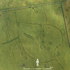
- Flat-topped and sub-rectangular in outline, c. 0.6m high. Abutts Bank 05. 384112.86E - 465201.98N - 463.94M This was allocated M02 in Martlew R. 2007. Langcliffe Scar Local Nature Reserve. Archaeological Survey. Yorkshire Dales Landscape Research Trust.
-
- Hugh Fiske
- 18-8-2016
Dating Narrative
-
- This mound is one of 18 mounds that were identified within and between the Victoria Camp earthworks during an aerial and topographic survey by Roger Martlew in 2007. They are part of a landscape that is assigned to be general Iron Age/Romano British, although there might also have been earlier phases of use of the area. Because of its large size and prominent position that makes it visible ‘on the skyline from wide across the Northern field and beyond’, this particular mound is likely a burial mound. It is particularly interesting as it associated with a long bank (B05) and its form resembles more that of a raised platform, which suggests that it might also be a collapsed structure (Martlew, R. D. 2007. Langcliffe Scar Local Nature Reserve Archaeological Survey 2007. Yorkshire Dales Landscape Research Trust).
-
- Johanna Ungemach
- 29-9-2016
Matrix
-
- [not set]
- [not set]