Basic Information
- Walling 02
Contexts
-
Context: UTU_4001
- Victoria Camp
- Hugh Fiske
- 18-8-2016

Narrative
-
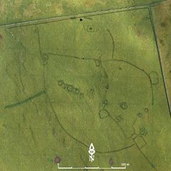
- Short length of coursed stonework visible in bank of loose stones: collapsed bield? 383990.86E - 465151.72N - 457.63M This was allocated W02 in Martlew R. 2007. Langcliffe Scar Local Nature Reserve. Archaeological Survey. Yorkshire Dales Landscape Research Trust.
-
- Hugh Fiske
- 18-8-2016
Dating Narrative
-
- This wall is one of three wallings that were investigated by an aerial and topographic survey by Roger Martlew in 2007. They are part of a landscape that is assigned to be general Iron Age/Romano British, although there might also have been earlier phases of use of the area.
-
- Johanna Ungemach
- 29-9-2016
Matrix
-
- [not set]
- [not set]