Basic Information
- Hollow 03
Contexts
-
Context: UTU_4001
- Victoria Camp
- Hugh Fiske
- 18-8-2016

Narrative
-
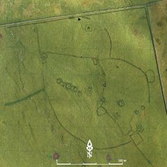
- Oval depression, c. 3m x 2m, on the side of a natural gully; may cut through Bank 02. Probable candidate for the smelting site excavated by Alan King. 384213.57E - 465230.98N - 456.52M This was allocated H03 in Martlew R. 2007. Langcliffe Scar Local Nature Reserve. Archaeological Survey. Yorkshire Dales Landscape Research Trust.
-
- Hugh Fiske
- 18-8-2016
Dating Narrative
-
- This hollow is one of three circular and oval hollows that range between three and seven metres and were investigated by an aerial and topographic survey by Roger Martlew in 2007. They are part of a landscape that is assigned to be general Iron Age/Romano British, although there might also have been earlier phases of use of the area. This particular hollow was presumably excavated by Alan King in 1966. Despite the results being unpublished as well as unarchived, substantial quantities of barytes, malachites, haematite, slag and charchoal found in the hollow have been recorded. This suggests that the hollow was a clay-lined bowl furnace and therefore evidence for mineral working in the area (Martlew, R. D. 2007. Langcliffe Scar Local Nature Reserve Archaeological Survey 2007. Yorkshire Dales Landscape Research Trust).
-
- Johanna Ungemach
- 9-9-2016
Matrix
-
- [not set]
- [not set]