Basic Information
- Bank 05
Contexts
-
Context: UTU_4001
- Victoria Camp
- Hugh Fiske
- 18-8-2016

Narrative
-
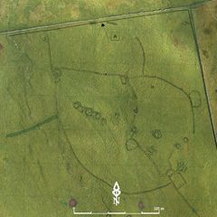
- Irregular earth bank 0.4 - 0.6m high and 1.0 - 1.5m wide, very occasional large stones (c. 0.6x0.4m max) visible. Butts Mound 02, Bank 09/Enclosure 07, Bank 11. 384089.89E - 465265.87N - 455.96M This was allocated B05 in Martlew R. 2007. Langcliffe Scar Local Nature Reserve. Archaeological Survey. Yorkshire Dales Landscape Research Trust.
-
- Hugh Fiske
- 18-8-2016
Dating Narrative
-
- This bank is one of 12 linear banks that were investigated by an aerial and topographic survey by Roger Martlew in 2007. They are part of a landscape that is assigned to be general Iron Age/Romano British, although there might also have been earlier phases of use of the area. Besides several enclosures, the banks are ‘by far the most extensive remains in the holding’ and have probably been constructed for stock control. In fact, Victoria Camp ‘may be part of a wider area of linear banks and enclosures’. The height of the banks ranges from 0.3 to 0.6m and most of them are irregular earth banks that don’t contain larger stones. Some banks form parts of enclosures, creating various formations, however, the exact chronology and character of associations is difficult to assess – only the overall layout of meeting banks may suggest any kind of dating narrative or relations. Unless comprehensive robbing and reuse of stones for surrounding modern enclosure walls took place across the area, it is likely that the banks have originally been topped by hedges rather than stone walls. This particular bank is very long and is associated with a possible burial mound or collapsed building (M02). It also butts two other banks (B09 & B06, and is being butt by two additional banks (B02 & B11), which suggests a later origin than the former, but earlier than that of the latter (Martlew, R. D. 2007. Langcliffe Scar Local Nature Reserve Archaeological Survey 2007. Yorkshire Dales Landscape Research Trust).
-
- Johanna Ungemach
- 29-9-2016
Matrix
-
- [not set]
- [not set]