Short Description:
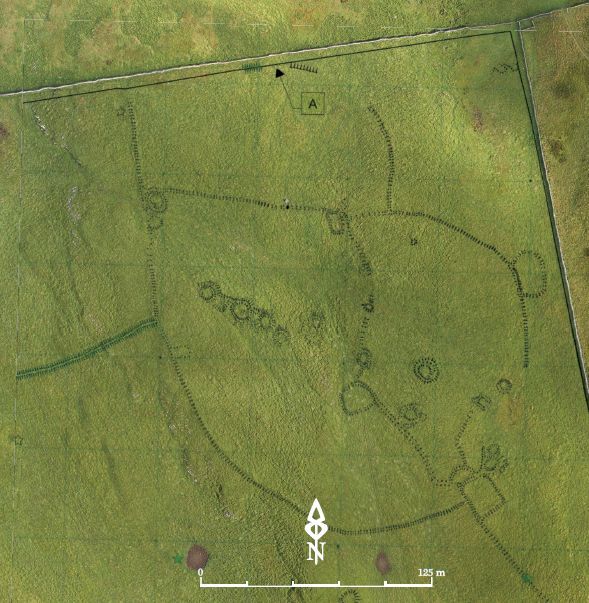
Victoria Camp
Issued to
Hugh Fiske | 18/08/2016
Interpretation
- No Interpretations
Sketch Photo
Description
- Aptoximately 440m AOD
Finds
Feature
-
Feature: UTU_08
- Bank 04
-
Feature: UTU_403
- Walling 02
-
Feature: UTU_405
- Bank 01
-
Feature: UTU_406
- Bank 02
-
Feature: UTU_407
- Bank 03
-
Feature: UTU_409
- Bank 05
-
Feature: UTU_410
- Bank 06
-
Feature: UTU_412
- Bank 08
-
Feature: UTU_413
- Bank 09
-
Feature: UTU_414
- Bank 10
-
Feature: UTU_415
- Bank 11
-
Feature: UTU_417
- Enclosure 01
-
Feature: UTU_418
- Enclosure 02
-
Feature: UTU_419
- Enclosure 03
-
Feature: UTU_420
- Enclosure 04
-
Feature: UTU_421
- Enclosure 05
-
Feature: UTU_422
- Enclosure 06
-
Feature: UTU_423
- Enclosure 07
-
Feature: UTU_424
- Enclosure 08
-
Feature: UTU_428
- Enclosure 12
-
Feature: UTU_429
- Enclosure 13
-
Feature: UTU_430
- Enclosure 14
-
Feature: UTU_431
- Enclosure 15
-
Feature: UTU_437
- Ring 01
-
Feature: UTU_438
- Ring 02
-
Feature: UTU_439
- Ring 03
-
Feature: UTU_440
- Ring 04
-
Feature: UTU_441
- Ring 05
-
Feature: UTU_442
- Ring 06
-
Feature: UTU_443
- Ring 07
-
Feature: UTU_444
- Ring 08
-
Feature: UTU_445
- Ring 09
-
Feature: UTU_446
- Ring 10
-
Feature: UTU_447
- Ring 11
-
Feature: UTU_448
- Ring 12
-
Feature: UTU_449
- Ring 13
-
Feature: UTU_451
- Mound 01
-
Feature: UTU_452
- Mound 02
-
Feature: UTU_453
- Mound 03
-
Feature: UTU_454
- Mound 04
-
Feature: UTU_455
- Mound 05
-
Feature: UTU_456
- Mound 06
-
Feature: UTU_457
- Mound 07
-
Feature: UTU_458
- Mound 08
-
Feature: UTU_459
- Mound 09
-
Feature: UTU_461
- Mound 11
-
Feature: UTU_462
- Mound 12
-
Feature: UTU_468
- Mound 18
-
Feature: UTU_469
- Cairn 01
-
Feature: UTU_470
- Hollow 01
-
Feature: UTU_471
- Hollow 02
-
Feature: UTU_472
- Hollow 03
-
Feature: UTU_475
- Quarry scoop 01
-
Feature: UTU_476
- Quarry scoop 02
-
Feature: UTU_480
- Shaft 01
-
Feature: UTU_481
- Shaft 02
-
Feature: UTU_567
- Mound 17
Plan
-
Plan: UTU_7
- Plan of Victoria Camp Drawn by Martlew R 2007 Langcliffe Scar Local Nature Reserve Archaeological Survey, Yorkshire Dales Landscape Partnership Trust.
- Admin Admin
- 5-1-2017
Record Details
- Not set
- Hugh Fiske 18-8-2016
- - - - -
- - -