- Trench over inner rampart.
Photos
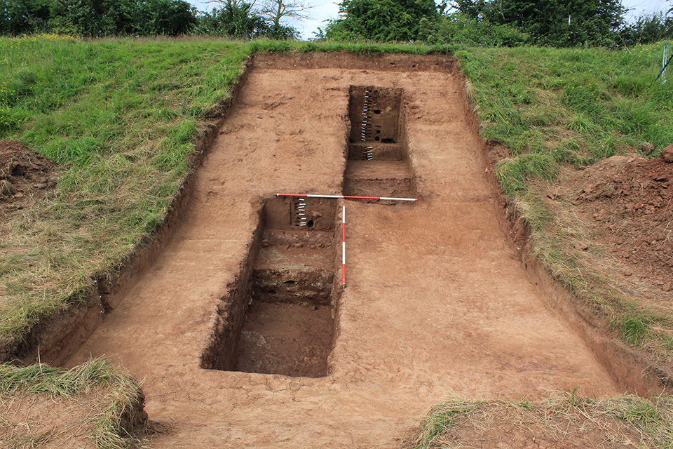
- Trench 16 also measured 10m x 4m and was aligned east to west. Topsoil was removed by machine with all subsequent excavation undertaken by hand within two 4m x 1m sondage in the centre of the trench. The earliest deposit encountered was hard red clay natural with frequent light yellowish grey mudstone inclusions (16010). It was observed throughout the trench and was excavated in the eastern sondage to confirm it as natural. A buried soil layer (16003) consisting of a 0.3m thick, loose mid yellowish-brown sand, overlay natural at the western end of the trench. This was sealed by a 0.02m thick relict turf-line (16008) recorded as a soft light greenish grey sandy clay with orange mineralization on top. These buried soil horizons predate the construction of the monument. Two features were identified in Trench 16: the monument’s ditch F1601 and its inner bank F1602. The ditch occupied approximately two thirds of the trench and was defined by its cut [16012] through the buried soils 3m from the western end of the trench. This linear cut was aligned north to south with a sharp break of slope at the top and moderately steep sloping, east-facing, side. The top of the cut was seen following removal of the topsoil at a height of 11.5m AOD – 3m from the western limit of excavation – and was recorded to a depth of 9.4m AOD at its deepest in the east. The earliest fill of the ditch was a 0.25m thick, firm dark reddish brown silty clay (16007). This was directly beneath a 0.5m thick, hard mid reddish brown silty clay with very occasional small round mudstone inclusions (16011). Stratigraphically the next deposit to fill the ditch was a firm dark reddish brown sandy clay (16005) that was excavated from higher up the side of the ditch. The ditch was finally filled by a firm light reddish brown clayey silt with occasional small round mudstone inclusions (16006), which was visible following cleaning after the machine removal of topsoil from the eastern half of the trench. The bank comprised two layers. The earliest was a 0.4m thick, firm light brown sand with occasional small red clay patches (16004), which was sealed by a clay capping layer (16002) comprising firm dark brownish red clay with occasional sub-angular stones and sandy mottled patches. This later deposit survived to a thickness of 0.85m at the western edge of the trench, petering out 2m to the east. The latest deposit found was a 0.15m thick, firm mid brownish red clay (16009) found directly beneath the topsoil and observed in the south-facing trench baulk section. This layer was morphologically similar to the clay bank capping and is interpreted as slump material. The upper fills of the ditch produced small abraded assemblages of 13th century pottery (Ham Green Wares and Brill/Boarstall Wares) suggesting that it had filled by the erosion of medieval agricultural soils, as is proposed to be the case with the ditch fills in Trench 15. The more compact, clay fills towards the base of the ditch are likely derived from earlier episodes of bank erosion.
3-D Models
Plan
Section
Contexts
-
Context: OBC_16001
- Topsoil
- Chris Casswell
- 22-6-2017
-
Context: OBC_16002
- Clay capping on top of inner bank
- Tom Stafford
- 22-6-2017
-
Context: OBC_16003
- Buried soil
- Sarah Tucker
- 30-6-2017
-
Context: OBC_16004
- Sandy bank deposit
- Chris Casswell
- 22-6-2017
-
Context: OBC_16005
- Ditch fill
- Chris Casswell
- 22-6-2017
-
Context: OBC_16006
- Upper ditch fill
- Chris Casswell
- 22-6-2017
-
Context: OBC_16007
- Basal fill of ditch
- Wendy Lyons
- 29-6-2017
-
Context: OBC_16008
- Relict turf-line above buried soil
- Christian Day
- 30-6-2017
-
Context: OBC_16009
- Clay slump on north side of trench
- Justin Vallance
- 30-6-2017
-
Context: OBC_16010
- Geological clay and mudstone
- Mary Knight
- 30-6-2017
-
Context: OBC_16011
- Stony ditch fill
- Chris Casswell
- 2-7-2017
-
Context: OBC_16012
- Hillfort ditch
- Ken Carruthers
- 2-7-2017
- Pamela Thom 21-6-2017