- Trench over outer rampart.
Photos
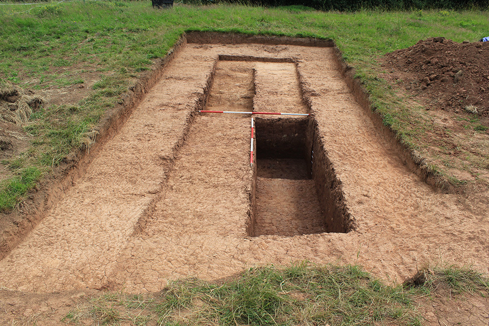
- Trench 15 was aligned approximately east to west and measured 10m x 4m. Initially the trench was machine-excavated to remove topsoil, thereupon all further groundwork was undertaken by hand within two 4m x 1m sondages. These areas were excavated down to a hard red clay natural with very occasional sub-rounded mudstone inclusions (15007), observed within both sondages, but limited to the east end of the western one because further excavation would have resulted in working in unsafe conditions due to the depth of the ditch. Overlying the red clay natural at the eastern end of the trench was a further band of natural (15003), comprising hard light yellowish grey sand clay with very occasional fragments of degraded mudstone and flecks of manganese. No bank was identified in the trench and the only archaeological feature encountered was the ditch of the monument F1501. The cut of this ditch [15006] was found 1.7m from the eastern end of the trench and was oriented roughly north to south. It was a linear shape in plan and had a sharp break of slope at the top with shallow sloping sides down to the west. It was not possible to hand excavate down to the base of the ditch, but a hand-auger survey was undertaken within the trench to identify it. An underlying deposit of hard red clay was encountered approximately 1m east from the western edge of the excavation area at a depth of 8.9m AOD – this was the greatest depth at which the auger was refused and it is possible that the deposit encountered represents bank slump into the base, which would also cause the auger to be refused. The earliest fill of the ditch identified from within the hand-excavated sondages was compact dark reddish brown sandy clay with very occasional flecks of manganese (15005), measuring a maximum thickness of 0.32m. Overlying this deposit was a 0.27m thick fill of the ditch comprising compact mid brownish red clay (15004). In turn, these fills were found beneath a 0.57m thick, compact mid brownish red silty clay (15002) representing the final phase of ditch fill identified within the trench. Pottery was recovered from all three fills of the ditch: the earliest contained two sherds of 12th century fabrics, while the later ones contained a larger assemblage of material dating their deposition to no later than the 14th century. The presence of medieval pottery from the earliest fill raises the question of the date of the monument itself. The 12th century pottery was found in the earliest deposit in the ditch itself, but does this make its construction medieval? It seems more likely that either these sherds were introduced from the deposit above, and should therefore be considered intrusive, or perhaps that this fill does not represent the basal fill of the ditch. All the pottery is very abraded and considered to most likely be part of a ploughsoil assemblage, which supports the supposition that this is intrusive material.
3-D Models
Plan
Section
Features
-
Feature: OBC_1501
- Ditch
Contexts
- Mary Jane Steer 21-6-2017