- The Western Area
Photos

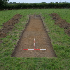
- Trench 12 was inserted in the centre-north of the Western Area on an E-W orientation and measuring 20 x 3 metres. Topsoil (12001) was removed by machine, coming down onto an archaeologically sterile natural layer. A continuation of the water channel observed in Trench 13 was identified, but no artefacts were recovered from a sondage excavated to ascertain it’s depth, and no further excavation was conducted within the trench.
3-D Models
- No models found for this item
Plan
-
Plan: LA_7
- Post-Ex plan of trench 12 drawn at 1:20
- Ben Swain
- 22-7-2014
Section
- No records attached.
Features
- No records attached.
Contexts
-
Context: LA_12001
- Topsoil Deposit
- Kezia Evans
- 9-7-2014

- DigVentures 12-12-2014