Short Description:
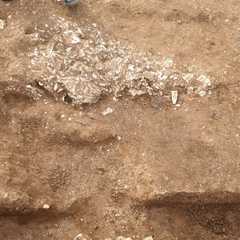
triangle of rubble in north west of trench
Issued to
Chris Swindells | 15/08/2021

Interpretation
-
- Rubble spread within the middle of a possible entrance way to a roman structure. Potentially related to the demolition of the building
-
- Ben Swain
- 21-8-2021
Description
- Very compact
- Mid Reddish brown
- Silty clay
- 50-70% inclusions of angular small to medium sized chalk/limestone pieces
- Length - 1.10m Width - 0.55m Thickness - 0.12m
- Hand Ex/dry
Finds
Feature
- No records attached.
Plan
-
Plan: ELM_11
- Post ex plan of Trench 4, new area exposed in 2021. 1:50. ELM21 plan sheet no. 1 and 2
- Freya Leaf
- 22-8-2021
Record Details
- Not set
- Chris Swindells 15-8-2021
- - - - -
- - -
